

Litchfield National Park is perched near the north-west corner of the Top End, and because of its relatively diminutive size of 1500 square kilometres, it is often referred to as a mini-Kakadu.
It is not, however, mini in what it has to offer; it is simply more condensed. The Tabletop Range sandstone plateau is deeply carved by spring-fed creeks like the Florence, and by rivers such as the Reynolds, the Adelaide and the Finniss, creating a tiered and sliced landscape with a splendour all its own.
The most popular destinations in the park are accessible by 2WD; indeed, they are popular because they are easy to get to. Anyone visiting Litchfield should be sure to include these in their travels: the fascinating Magnetic Termite Mounds, the delightful Buley Rockhole tumbling into Florence Falls and the magnificent cascades of Tolmer Falls and Wangi Falls.
For those lucky enough to own a 4WD with high clearance, there are hidden, less-visited splendours. The Lost City is nature’s structural masterpiece, with stacked sandstone cubes and slabs teetering one on top of the other, and with weathered columns like those of a mysterious civilisation in ruins.
The upper section of the Reynolds River Track presents Blyth Homestead, the abandoned homestead of the Sergeant family, followed by Tjaynera (Sandy Creek) Falls where a lovely walk along a creek leads to a ravishing waterhole surrounded by a sandstone amphitheatre and fed by a plundering waterfall.
These destinations, and the rest of Litchfield, make for some great exploring along with some outstanding walks.
The Lost City can easily be done in one day, allowing time to wander the ‘ruins’, followed by a swim at nearby Buley Rockhole and Florence Falls. The Reynolds River Track to Blyth Homestead is worth a look on another day followed by Tjaynera Falls for lunch and a swim. A third day can be spent hitting the easier 2WD destinations. So, let’s have a closer look at Litchfield, moving from east to west in a big loop.
LITCHFIELD NATIONAL PARK CAMPSITES
If you are towing a caravan, it is best to set-up camp first at one of the van parks around Batchelor or at the Wangi Falls Van Park (no powered sites). Camper trailers and tents can also be set up at Florence Falls and Buley Rockhole; these are the closest campgrounds to the 4WD tracks.
The Litchfield Tourist Park is a pleasant, shady park closest to the north-east boundary of Litchfield (they make a great barramundi burger). Not having a van in tow makes it much easier to explore the park, not to mention negotiate the hairpin bends and steep ascents/descents mandating the 80km/h speed limit on sealed Litchfield Park Road.
As you drive, please watch out for wildlife such as the Northern Territory’s iconic frilled lizard sunning near (or on) the road.
MAGNETIC TERMITE MOUNDS
The Magnetic Termite Mounds should be your first stop, 17km beyond the eastern boundary of the park.
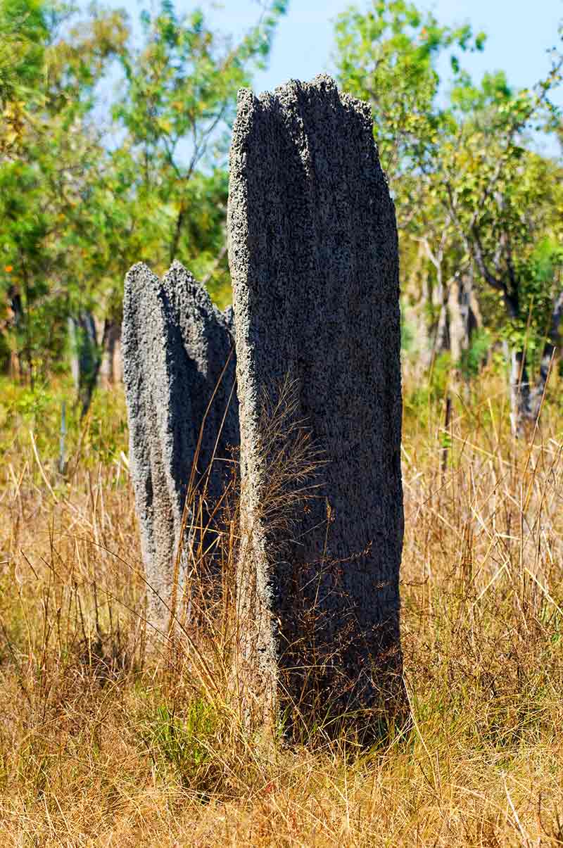
The information bay, explaining how the mounds’ north-south points with their broad walls facing east-west keep the residents cool through the day, is well worth a look before wandering along the boardwalk to a few of the termite mounds, with most of the mounds off in the distance. You’ll have the chance to see more termite mounds on the 4WD track to Tjaynera Falls.
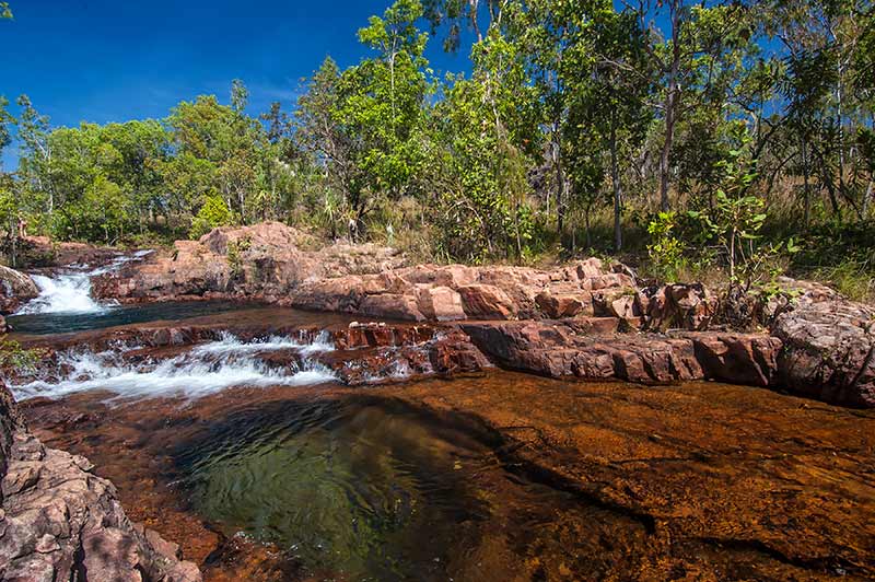
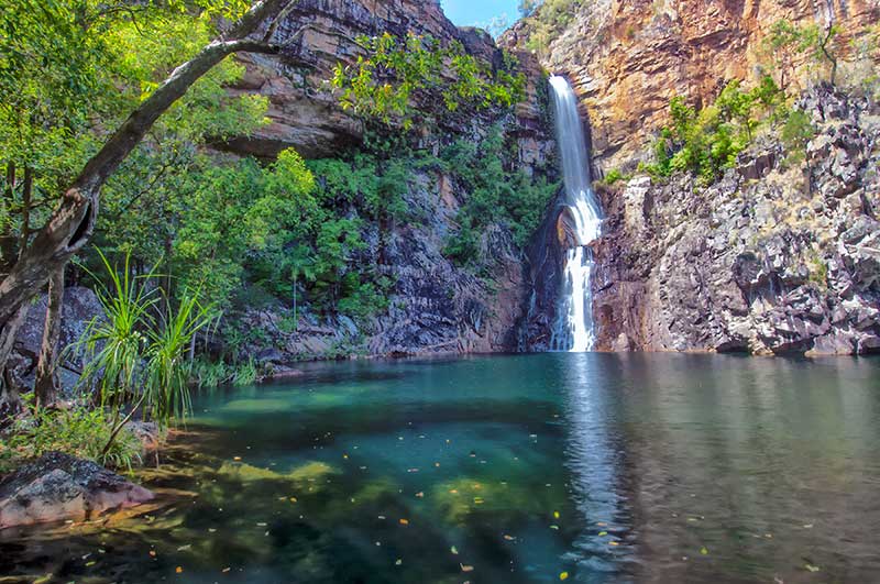
BULEY ROCKHOLE AND FLORENCE FALLS
Nine kilometres on is a turn-off to the north for Buley Rockhole (3km) and Florence Falls (another 1km). Buley offers a campground, a sensational 3.2km return bushwalk to Florence Falls, and safe swimming in a series of bubbling waterholes that rival luxury resort spas.
Florence Falls has a 4WD campground with a couple of bushwalks and a steep stairway with 125 steps dropping down to a safe swimming hole at the base of Florence Falls. On a hot day, it is sublime.
THE LOST CITY
Back on the main sealed road, it is 7km to the Lost City 4WD track heading south into the park. Stop straight after turning onto the track and engage 4WD for the moderately easy drive ahead.
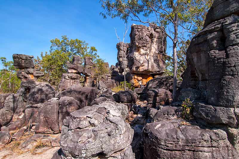
As you travel, watch for flocks of galahs and corellas screeching and careening through the air like pink and white confetti, or resting quietly on tree branches. At 9km you’ll start to see the stacked rock formations that give the Lost City its name.
At another 2km, the track will drop in a mild descent and you’ll find the car park (after all, it wouldn’t be a city without a car park, would it?). Pay close attention to where you go walking and carefully follow the arrows as it would be very easy to become disoriented and lost in this rocky city. There is an emergency call device should something go wrong. Follow the same track out again and remember to disengage 4WD before getting back on the bitumen.
TOLMER FALLS
Continue another 10km on the main sealed road to the Tolmer Falls turn-off. The look-out provides a sensational view of the falls, and locals say that during the Wet you can feel the mist driven upwards by the thundering water.
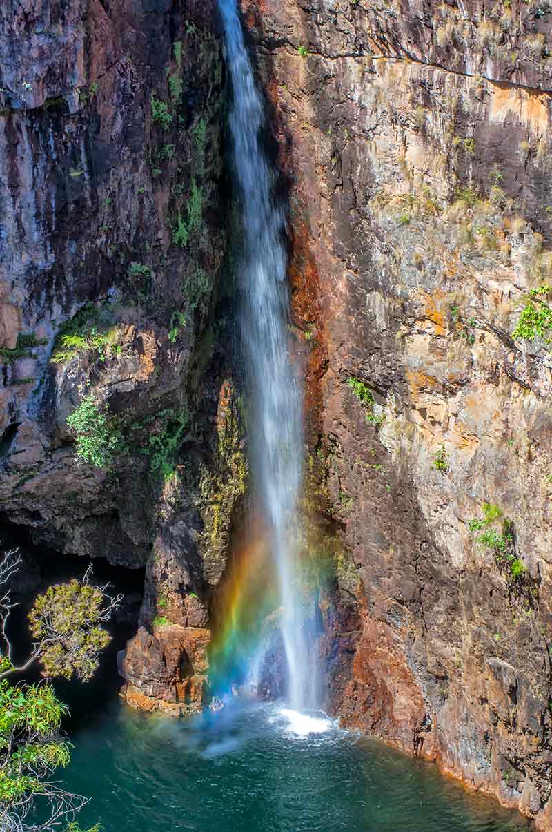
There is a 1.6km return bushwalk around to the top of the falls, but there is no access to the base to help protect several species of bats living in caves along the cliff walls. For those who want to take photos, the best light is in the afternoon. Greenant Creek is 2km past Tolmer and offers a bushwalk that will have you panting for a swim; however, this isn’t permitted in the lower plunge pool.
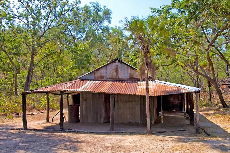
BLYTH HOMESTEAD
It is only a short 1km to the next 4WD adventure on the Reynolds River Track (aka the Litchfield Daly River Road). Again, stop to engage 4WD as soon as you turn south off the bitumen. The action gets going within 1km with a fairly deep creek crossing over a bed of large, rounded rocks – drop into low range and keep those revs up and steady without stopping mid-stream. Contemplate the crocodile warning sign before you think about walking the creek.
It is another 6km of dip-and-bend to the Blyth Homestead Track branching for 1km to the north. There will be a creek crossing almost immediately which will require low range and caution as it tends to be murky and, without a metre marker, it is difficult to gauge the depth – expect a loose riverbed with small pebbles. This is when the tried and true technique of observing someone else’s crossing, before you go, comes in very handy.
The Blyth Homestead is certainly worth a look to see how the Sargent family drained a living out of a nearby creek by mining tin. They settled there in 1929 and stuck at it for over 30 years until they abandoned their shack in the early 1960s.
The restored homestead features a number of historic memorabilia, including a photo album documenting the family’s life. There is a short walk to the tin mine with an information plaque, then it is back through that creek crossing to the main track heading south.
TJAYNERA FALLS
And now it is only 2km to access the 4WD highlight of the park. Turn north on the track to Tjaynera (Sandy Creek) Falls and follow along for 1km, noting a network of termite mounds rising out of the landscape.
There will be a car park at the end of the track, along with a small campground. Get some walking shoes on, pack some water, a picnic, bathers and a towel and walk beside Sandy Creek for 1.7km to a plunge pool at the base of Tjaynera Falls.
Linger here for a picnic and then enjoy a refreshing swim in the swimming hole. It is nice that there is camping here, but with a 3.4km return walk from the campground to the falls, it is a case of being so near and yet so far. Return to the Reynolds River Track the same way you came.
Now, at the junction, you can go back the easy way, or you can proceed south the hard way on the 4WD-only Litchfield Daly River Road. We say the hard way not because the track is all that difficult (though it couldn’t be called easy) but because of the two crossings at the east branch and the main branch of the Reynolds River.
Be sure to check with the ranger before attempting this section of track that continues for 6km to the first Reynolds River crossing, then another 11km to Surprise Creek Falls (with a campground and a bushwalk) and then another 16km to the sealed Daly River Road.
You should count on a depth of at least 1m of water on the Reynolds River crossings, and depending on the time of year, count on several other creek crossings including Tableland Creek. If time is short and you want to have a go, or you want a night or two of secluded camping, then drive down to Surprise Creek and back again (for a total of four Reynolds River crossings). This track is best done in a convoy of at least two 4WDs.
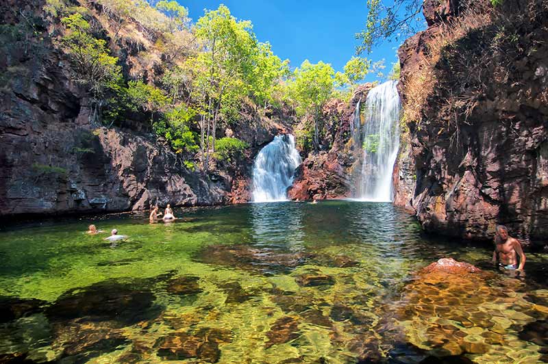
And the easy way: return north on the track to the sealed road and after disengaging 4WD at the bitumen, continue north for 8km to Wangi Falls. If you have already set-up camp here, then you are home. If not, it would be a shame to miss this part of the park, even if it does tend to be the most crowded. The swimming in the massive plunge pool at the base of the falls is fantastic. There is a boardwalk around the edge of the swimming hole that leads to a lookout and a walk through a monsoon rainforest.
BACK TO CAMP
Return to your campsite at your leisure or exit the park along a 59km unsealed section of Litchfield Park Road between Walker Creek and Cox Peninsula Road. Just outside the north-west boundary of the park is Litchfield Safari Camp, where you could spend a night to explore the Upper & Lower Cascades and the Bamboo Creek Tin Mine inside the park.
If you are travelling this way, why not also spend a few nights camping at the Tumbling Waters Holiday Park or the Lakes Resort Caravan Park to include a visit to The Territory Wildlife Park and Berry Springs Nature Park?
Litchfield: mini is size, maxi in splendour.
FAST FACTS
- Litchfield National Park
- Guided activities: Parks Alive brochure, Facebook page.
- Ranger station: (08) 8976 0282 or (08) 9999 2077.
- Bird species list.
- Road report.
- Nearest supplies including fuel: Batchelor.
- Bring a tarp for sitting on the ground as bush mites can transmit scrub typhus.
- Heed all estuarine crocodile warning signs on the 4WD-track creek crossings; even if a sign isn’t present, assume that a croc might be.
- Emergency call devices are located at the Lost City and Tjaynera (Sandy Creek) Falls.
- Camping: Florence Falls 2WD and 4WD tent and camper trailer campgrounds with toilets and showers; Buley Rockhole tent and camper trailer campground with toilets; Tjaynera (Sandy Creek) Falls 4WD tent campground with toilets and showers; Wangi Falls Kiosk and Van Park with toilets and showers, no power, (08 8978 2861).


