

If you have ever stood at the top of Ubirr in Kakadu National Park and gazed over the verdant wetland below, perhaps the beauty of that landscape made you wish to explore it further. Since this outlook extends into Arnhem Land, there is only one way to experience it, and that is on the drive through that remote region, beginning at Cahills Crossing and extending into Garig Gunak Barlu National Park (GGBNP) on the Cobourg Peninsula.
Careful planning is required, as it is for any real adventure. First, download the Garig Gunak Barlu National Park Fact Sheet and have a thorough study of the maps and information. Also check the Northern Territory Parks website.
ARNHEM LAND PERMITS
The road through Arnhem Land is only open during the Dry, May through October. A free permit to travel through the region is required in advance. School holidays are busy so apply early to Permit and Concessions Unit, PO Box 496, Darwin, NT 0831; phone (08) 8999 4814 or email pwpermits@nt.gov.au.
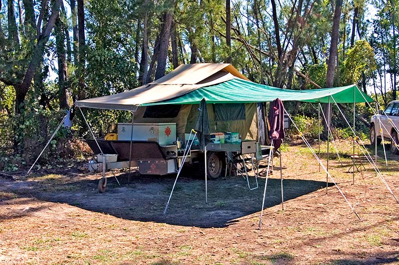
Time this permit with the camping and road entry fee, which must be paid six weeks in advance. Current fees are $232.10 allowing five adults to stay seven nights (children under 16 are free). This is a Parks department fee. Camping sites have toilets, bore water showers, picnic tables and barbecues. One of the two areas is a generator zone.
This is a remote peninsula with no supplies at all, including no fuel, no food and no drinkable water. It is a BYO everything destination. Don’t forget a well-stocked first aid kit, any medications you take, as well as lots of insect repellent, long-sleeved shirts and long pants to wear the instant the sun goes down. An extra tarp for shade is helpful, although some of the sites have shade sails. Alcohol is permitted in the park but may not be opened or consumed when travelling through Arnhem Land.
There is no mobile reception, but there is a public phone at the Black Point Ranger Station that only accepts Telstra phone cards – add this to your list of must-haves.
For fun and relaxation, you might want to take a few good books, some board games, binoculars for bird-watching, cricket gear for a game on the air field, fishing gear for shore fishing (ask the ranger about the best places to try) and, if the budget allows, a Black Point Boat Tour with Cobourg Fishing Safaris. These are run for Smith Point campers only.
The full day Explorer Tour includes a visit to Victoria Settlement, three hours of fishing, and enough time to enjoy other marine-based activities. If you are a glutton for fishing, there is also a full day fishing charter. Phone 1300 148 809 to book in advance.
FUEL ON THE COBOURG PENINSULA
Access to GGBNP is by 4WD only; tents, offroad campers or camper trailers, and/or a croc-proof boat may be towed in. If you have a small offroad van, you could try calling the Permit Office (08 8999 4814) to see if you are allowed to tow it in; the information on the website is somewhat contradictory, but standard vans and large vans are certainly not permitted. Caravans can be stored in Jabiru at the Aurora Kakadu Lodge and Caravan Park (08 8979 2422).
Calculate your vehicle’s fuel consumption carefully: it is 310km from Jabiru (the last chance to buy fuel) to Black Point in the national park (620km return). Extra fuel is required for trips between Black Point, Smith Point, the campground (about 5km each way) and for the Coastal Drive.
The fact sheet provides accurate distances for fuel calculations. Your vehicle must be in tip-top condition but carry tools, spare parts and at least one spare tyre. You can try calling the Black Point Ranger to check on road conditions before you leave, but the rangers are not always available.
CAHILLS CROSSING
Keep in mind that Cahills Crossing is tidal and high tides can, and have, swept vehicles downstream. Check a tide table before you cross Cahills (coming and going). If you must wait a couple of hours before you can cross, it is certainly better to be safe than sorry! If possible, try to leave in the morning, counting on a three-to-four-hour drive and leaving time to set-up camp before you need to worry about the predatory insects.
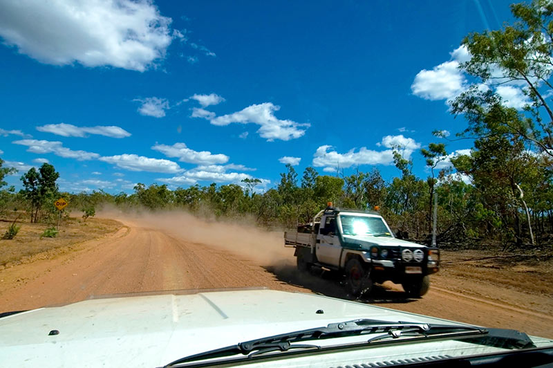
From Cahills, expect an unsealed gravel road with heavy corrugations, loose gravel and bulldust. There are several creek crossings, most with metre markers. If you get lucky, the road will have been graded recently and you will have a fairly easy drive. At the end of the wet before a grader gets through, it can be rough.
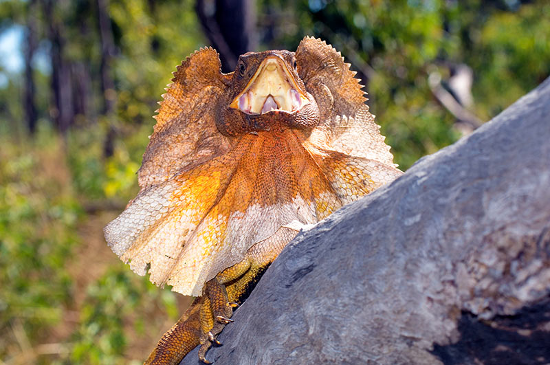
Your adventure begins the moment you are on the Arnhem Land side of Cahills Crossing. Your permit does not allow you to stop along the way but no one said you can’t slow down to take in the stunning scenery with numerous creek crossings. Mind the abundant wildlife that can be seen at any time along the way; it would be tragic to hit any animal that lives in this remote region.
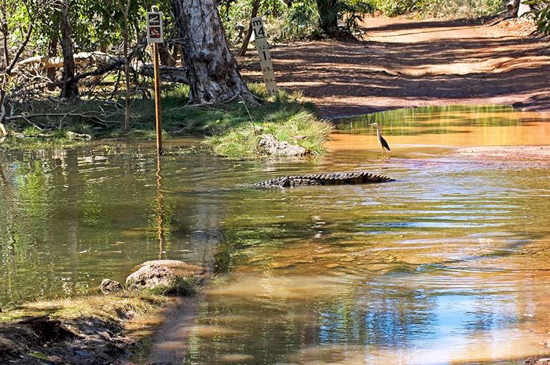
About 34km (from Cahills), Murgenella Road will veer sharply to the left. Ignore the access road straight ahead. At 53km you will approach Cooper Creek – do not get out to walk the crossing due to the ever-possible presence of estuarine crocodiles. Do stop to check the metre marker, drop into 1st gear and make your way across this magnificent scene, rather like driving through an iconic landscape painting. Same again at 90km for the Angulari Creek crossing.
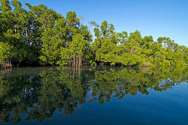
At 134km you will encounter Murgenella Creek, possibly the prettiest on the entire drive. Take it slow as the exit can be a bit rough and rocky. Don’t be surprised to spot the resident croc and several white egrets hunting along the shoreline. At 156km, turn left at the “Cobourg 120km” sign.
At 160km, note the start of a series of road signs indicating sharp turns and blind bends. Also, the gravel road can be slippery, and oncoming traffic (if there is any) might not take the bends as cautiously as they should. The national park entrance is at 177km. Here, the road narrows.
Black Point is at 268km. The Culture Centre (well worth a visit), the telephone and the nearby boat launch are all here. Note that the pier is closed. Check in with the ranger before you head to the campground to set-up. At 270km is a junction: left for Smith Point to catch the sunset, right to the campgrounds just past the airstrip.
SMITH POINT SUNSET
So, what is there to do once you are all organised? The first evening must include a sunset from Smith Point, looking out over the limpid waters of the Arafura Sea. This will, no doubt, become a nightly ritual, and you are sure to meet your fellow campers. Ask the ranger about shore fishing at places like Caiman Creek. There is a wetland walk starting from the ranger station, and there is a 4WD Coastal Drive south of the camping area; again, ask the ranger before heading off on this drive.
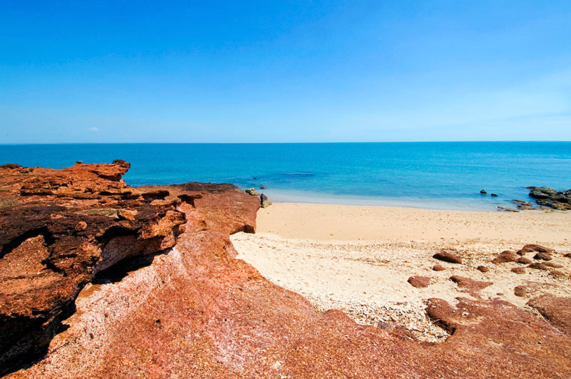
You can also wander along the shoreline, staring in wonder at the glittering water swirling in shades of aquamarine, and lamenting that you can’t go for a swim due to crocodiles, sharks, stonefish, blue-ringed octopus and marine stingers. At low tide, you can look for small marine life in the rock pools, and with binoculars, you can look out to sea for large marine life and numerous bird species, shorebirds in particular. In fact, the Cobourg Peninsula is a Ramsar Wetland of International Importance and an International Site of Conservation Significance.
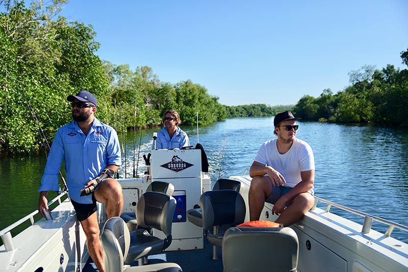
If you do have a croc-proof boat, check with the ranger before you venture anywhere; this is a remote area, and you must know what you are doing. The boat launch is at Black Point. If you don’t have a boat, and since you will have gone to a lot of trouble to make this all happen (and if the budget allows), consider a marine outing with an expert local guide: try the half-day Victoria Settlement Tour, the full day Cobourg Peninsula Boat Tour or the full day fishing tour (as mentioned above).
You will see places you would never find on your own. Although the 4,500-square-kilometre national park encompasses the entire peninsula, its surrounding waters and offshore islands, campers are restricted to the Black and Smith Point area. A boat is the best way to truly appreciate what this dazzling region has to offer.
Garig Gunak Barlu National Park is a place where you learn the art of relaxing, of understanding the importance of conserving nature and of taking the time to just stand in awe of beautiful scenery. If you truly want to disconnect from the madness of the modern world, this is the place for you.
– Images: Steven David Miller / Natural Wanders
CAUTION
- No swimming due to the presence of estuarine crocodiles (also sharks, sea snakes, stonefish, blue-ringed octopus and box jellyfish).
OTHER INFORMATION
- Boating
- Fishing
- Fishing and Boating App
- Black Point Ranger Station, phone (08) 8979 0244
- Avenza Maps App for two Garig Gunak Barlu NP maps and a Cobourg Peninsula map
- The YouTube video footage by Rough Roads and Insane Fishing Cobourg NT Part 1 does a good job of showing you what to expect


